

WEATHER warnings have been issued by the Met Office as East Hampshire looks set to feel the full force of the ‘Beast From The East.’
The district has had snow showers and freezing temperatures over the last few days but weather forecasters are warning residents to prepare for more severe conditions towards the end of this week.
An amber weather warning has now been issued for the period of 2pm on Thursday afternoon through until 8am on Friday morning.
Weather fronts are expected to push up from the south and when they hit the cold air already sitting over the country, any precipitation is likely to turn to snow.

-Cllr-Lulu-Bowerman-Tim-Lawton--Image-LDRs.jpeg?width=209&height=140&crop=209:145,smart&quality=75)

The latest forecasts are suggesting the west country and south Wales will get the worst of the expected bad weather but disruption can also be expected in East Hampshire over the 18 hour period covered by the Amber warning.
The Met Office warning stated: “There is the potential for a spell of snow, moving northwards over southern Britain on Thursday, to intensify and become heavy on Thursday afternoon/evening as it spreads north.
“As it does so, some places could also see significant ice build-up overnight into Friday. This is likely to be accompanied by strengthening easterly winds.
“Long delays and cancellations to public transport could occur, whilst some roads may become blocked by deep snow, stranding vehicles and passengers.
“Long interruptions to power supplies and other utilities could occur.”
According to the Met Office website, Amber weather warnings mean there is an increased likelihood of bad weather, which could potentially disrupt people’s plans and possibly cause travel delays, road and rail closures, interruption to power and the potential risk to life and property.
Amber means you need to be prepared to change plans and protect yourself, your family and community from the impacts of the severe weather based on the forecast from the Met Office.
Assessing the situation which could impact on the district, the Met Office’s chief forecaster said: “A weather system is expected to move slowly north through Thursday, intensifying and pushing north across the warning area from Thursday afternoon.
“As it comes into contact with the very cold air resident over the UK, it has potential to produce widespread snow, accompanied by strong to gale force winds.
“As less cold air follows from the south, there is a chance of snow turning to freezing rain, bringing an additional significant ice risk.
“There is still uncertainty in how this system will develop, but there is a chance that the combined effects of snow, strong winds and ice will lead to severe impacts.”
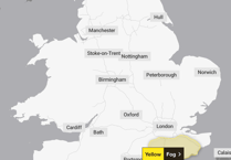
Yellow warnings are also in place for further potential snowfall on Friday and Saturday across the district.
For the latest updates on the weather situation for East Hampshire keep checking the Post’s websites. Please send your snow pictures and stories to: [email protected] or call the newsdesk on 01730 232605.
Comments
This article has no comments yet. Be the first to leave a comment.